E-Bike trails in Osttirol

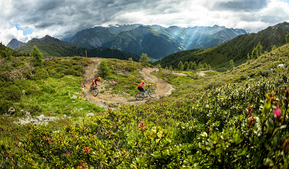
Discover Osttirol on an e-bike in a relaxed and environmentally friendly way. Thanks to motorised support, inclines, headwinds and long journeys are a thing of the past and you can enjoy the exciting nature all around you. Good signposting throughout, the magnificent mountain scenery and breathtaking landscape as well as the sunny weather will provide you with unforgettable mountain moments in Osttirol!


After an extensive tour on your e-bike, you can take a break at a rustic mountain hut and indulge in culinary delights. You're sure to get one or two insider tips for your next tour for free. And to make sure your bike doesn't run out of energy, there is a comprehensive network of e-bike charging stations available. Here you will find detailed information about the route length, altitude profile and difficulty level of the best e-bike tours in Osttirol, and the GPX data for each route is also available here. So - get on your bike and off you go!

filter results
more filter otions
starting point:
Leisach-Schloß Bruck (725m)
destination point:
Leisach (712m)
distance
15.6 km
🔋
altitude meters uphill
833 hm
🞽
difficulty
average
starting point:
Obertilliach-Bundesstr. (1440m)
destination point:
Tilliacher Joch (2094m)
distance
10.3 km
🔋
altitude meters uphill
750 hm
🔋
altitude meters downhill
750 hm
🞽
difficulty
average
starting point:
Assling-Parkplatz Hochstein (680m)
destination point:
Parkplatz Hochstein (680m)
distance
31.1 km
🔋
altitude meters uphill
1390 hm
🞽
difficulty
difficult
state: closed
starting point:
Tessenberg/Fronstadl (1340m)
destination point:
Fronstadlalm (2030m)
distance
15.4 km
🔋
altitude meters uphill
790 hm
🔋
altitude meters downhill
690 hm
🞽
difficulty
average
starting point:
St. Oswald (Kartitsch) (1358m)
destination point:
Dorfberg (1965m)
distance
13.8 km
🔋
altitude meters uphill
600 hm
🔋
altitude meters downhill
600 hm
🞽
difficulty
average
starting point:
Assling-Sportzentrum Thal (800m)
destination point:
Sportzentrum Thal (800m)
distance
18.8 km
🔋
altitude meters uphill
850 hm
🞽
difficulty
average
starting point:
Leisach (712m)
destination point:
Sternalm (1505m)
distance
11 km
🔋
altitude meters uphill
760 hm
🞽
difficulty
average
starting point:
Kals am Großglockner (1330m)
destination point:
Kals (1330m)
distance
12.8 km
🔋
altitude meters uphill
584 hm
🔋
altitude meters downhill
570 hm
🞽
difficulty
average
starting point:
Kals am Großglockner-Parkplatz Dorfertal (1500m)
destination point:
Pifangalm (2250m)
distance
18.2 km
🔋
altitude meters uphill
906 hm
🔋
altitude meters downhill
914 hm
🞽
difficulty
difficult
starting point:
Dölsach-Schwimmbad (650m)
destination point:
Ederplan (1190m)
distance
22 km
🔋
altitude meters uphill
1412 hm
🔋
altitude meters downhill
1412 hm
🞽
difficulty
difficult
starting point:
Virgen (Tratte) (1100m)
destination point:
Würfelehütte (1380m)
distance
4.3 km
🔋
altitude meters uphill
280 hm
🔋
altitude meters downhill
280 hm
🞽
difficulty
average
starting point:
Kals am Großglockner-Großdorf (1360m)
destination point:
Gornalm (1930m)
distance
11.4 km
🔋
altitude meters uphill
612 hm
🔋
altitude meters downhill
613 hm
🞽
difficulty
average
starting point:
Anras-Feuerwehrhaus Mittewald (900m)
destination point:
Linderkaser (1750m)
distance
10 km
🔋
altitude meters uphill
820 hm
🔋
altitude meters downhill
860 hm
🞽
difficulty
difficult
starting point:
Toblach
destination point:
Nikolsdorf
distance
63 km
🔋
altitude meters uphill
50 hm
🔋
altitude meters downhill
600 hm
🞽
difficulty
easy
starting point:
St. Jakob im Defereggen-Kirchl "Maria Hilf" (1422m)
destination point:
Hintere Alpe Stalle (2046m)
distance
11.1 km
🔋
altitude meters uphill
570 hm
🔋
altitude meters downhill
570 hm
🞽
difficulty
average
starting point:
Heinfels-Tessenberg (1320m)
destination point:
Tessenberger Alm (1950m)
distance
5.3 km
🔋
altitude meters uphill
630 hm
🞽
difficulty
average
starting point:
Lienz (675m)
destination point:
Matrei (980m)
distance
53 km
🔋
altitude meters uphill
300 hm
🔋
altitude meters downhill
300 hm
🞽
difficulty
easy
starting point:
Hopfgarten im Defereggen-Blosbrücke (1102m)
destination point:
Bloshütte (1795m)
distance
13.8 km
🔋
altitude meters uphill
680 hm
🔋
altitude meters downhill
680 hm
🞽
difficulty
difficult
starting point:
Innervillgraten (1380m)
destination point:
Innervillgraten (1380m)
distance
24 km
🔋
altitude meters uphill
720 hm
🔋
altitude meters downhill
720 hm
🞽
difficulty
average
starting point:
Assling-Dorfplatz (1125m)
destination point:
Dorfplatz Assling (1125m)
distance
16.8 km
🔋
altitude meters uphill
835 hm
🞽
difficulty
average
starting point:
Nussdorf-Debant-Zettersfeldtalstation (725m)
destination point:
Zettersfeldtalstation (725m)
distance
22 km
🔋
altitude meters uphill
1165 hm
🞽
difficulty
average
starting point:
Assling-Dorfplatz (1125m)
destination point:
Dorfplatz Assling (1125m)
distance
15.6 km
🔋
altitude meters uphill
995 hm
🞽
difficulty
average
starting point:
Hopfgarten im Defereggen-Wasserhalle (998m)
destination point:
Parkplatz Gumplalm (1660m)
distance
11.6 km
🔋
altitude meters uphill
660 hm
🔋
altitude meters downhill
660 hm
🞽
difficulty
average
starting point:
Assling-Dorfplatz (1125m)
destination point:
Assling - Dorfplatz (1125m)
distance
38 km
🔋
altitude meters uphill
1530 hm
🔋
altitude meters downhill
1560 hm
🞽
difficulty
difficult
starting point:
Talstation Brunnalm Bergbahnen
destination point:
Brugger Alm Jausenstation
distance
7.7 km
🔋
altitude meters uphill
400 hm
🔋
altitude meters downhill
400 hm
🞽
difficulty
average
starting point:
Hintere Stalle
destination point:
Jesach Alm
distance
1.9 km
🔋
altitude meters uphill
60 hm
🔋
altitude meters downhill
60 hm
🞽
difficulty
average
starting point:
Eingang Trojer Tal
destination point:
Gasser Kofel
distance
9.9 km
🔋
altitude meters uphill
510 hm
🔋
altitude meters downhill
510 hm
🞽
difficulty
average
starting point:
Eingang Trojer Tal
destination point:
Almgebiet Tögischer Bachl
distance
9.3 km
🔋
altitude meters uphill
460 hm
🔋
altitude meters downhill
460 hm
🞽
difficulty
average
starting point:
St. Jakob i. Def.
destination point:
Klammljock
distance
44 km
🔋
altitude meters uphill
980 hm
🞽
difficulty
average
starting point:
Lienz
destination point:
Lienz
distance
38 km
🔋
altitude meters uphill
1450 hm
🔋
altitude meters downhill
1400 hm
🞽
difficulty
average
starting point:
station Lienz
destination point:
station Lienz
distance
112 km
🔋
altitude meters uphill
5392 hm
🔋
altitude meters downhill
5396 hm
🞽
difficulty
difficult
starting point:
Lienz
destination point:
hut, Hochsteinhütte
distance
32 km
🔋
altitude meters uphill
1350 hm
🔋
altitude meters downhill
1350 hm
🞽
difficulty
average
starting point:
Adler Lounge
destination point:
Adler Lounge
distance
5.3 km
🔋
altitude meters uphill
248 hm
🔋
altitude meters downhill
252 hm
🞽
difficulty
average
starting point:
Goldried Bergbahnen
destination point:
Berggasthaus Goldried
distance
24 km
🔋
altitude meters uphill
1270 hm
🔋
altitude meters downhill
1260 hm
🞽
difficulty
average
starting point:
Parking area cable car Kals
destination point:
Parking area cable car Kals
distance
4.9 km
🔋
altitude meters uphill
156 hm
🔋
altitude meters downhill
153 hm
🞽
difficulty
average
starting point:
Parking area cable car Kals
destination point:
Parking area cable car Kals
distance
7.5 km
🔋
altitude meters uphill
115 hm
🔋
altitude meters downhill
109 hm
🞽
difficulty
easy
starting point:
Parking area cable car Kals
destination point:
Kerer Alm
distance
10.3 km
🔋
altitude meters uphill
493 hm
🔋
altitude meters downhill
495 hm
🞽
difficulty
average
destination point:
Lesachalm
distance
13.2 km
🔋
altitude meters uphill
654 hm
🔋
altitude meters downhill
655 hm
🞽
difficulty
average
starting point:
Parkplatz bei der Matreier Goldried Bergbahn
destination point:
Umbalfälle
distance
48.2 km
🔋
altitude meters uphill
1090 hm
🔋
altitude meters downhill
1090 hm
🞽
difficulty
average
starting point:
Sports area Gries
destination point:
Stabanthütte
distance
10.3 km
🔋
altitude meters uphill
500 hm
🔋
altitude meters downhill
500 hm
🞽
difficulty
average
starting point:
Parkplatz Lucknerhaus
destination point:
Lucknerhütte
distance
5.5 km
🔋
altitude meters uphill
327 hm
🔋
altitude meters downhill
326 hm
🞽
difficulty
difficult
starting point:
Parkplatz Hochstein
destination point:
Lifthütte Moosalm
distance
5 km
🔋
altitude meters uphill
330 hm
🔋
altitude meters downhill
330 hm
🞽
difficulty
average
starting point:
MTB-Route Bodenalm - Timmeltal Nr. 129
destination point:
Aussichtsplatz Wuneck
distance
18.4 km
🔋
altitude meters uphill
920 hm
🔋
altitude meters downhill
920 hm
🞽
difficulty
average
starting point:
St. Jakob i. Defereggen
destination point:
Jausenstation Trojeralm
distance
9.3 km
🔋
altitude meters uphill
400 hm
🔋
altitude meters downhill
400 hm
🞽
difficulty
average
starting point:
Sportplatz Tristach
destination point:
Karlsbaderhütte
distance
26.2 km
🔋
altitude meters uphill
1590 hm
🔋
altitude meters downhill
1560 hm
🞽
difficulty
difficult
starting point:
Parking space Schöne Aussicht
destination point:
valley Debanttal
distance
6.8 km
🔋
altitude meters uphill
320 hm
🔋
altitude meters downhill
270 hm
🞽
difficulty
average
starting point:
Parkplatz Golzentipp-Bahn
destination point:
Folmasai-Sattel unterhalb des Golzentipp-Gipfels
distance
9.1 km
🔋
altitude meters uphill
840 hm
🔋
altitude meters downhill
10 hm
🞽
difficulty
average
scroll for more

You may also be interested in

Am Ziel bei der Johannishütte
E-bike charging stations

In Osttirol you benefit from a comprehensive infrastructure of e-bike charging stations.

Biken Adler Lounge Bikepark Grossglockner
Mountainbike trails
Newsletter

Subscribe to our newsletter and receive the best tips every month for current offers, mountain tours, events and much more.