The Isel trail

Leisurely hiking by the last still free-flowing glacial river in the Alps

A unique route through a magical water wonder world with an individual choice of sections!


From the sunny Dolomites town Lienz in the green valley basin to the Arctic glacial gateway at the Hohe Tauern National Park. From a carefully cultured landscape into a secluded alpine wilderness. Always accompanied by the refreshing element of water, past water meadows, gravel bars, gorges, rapids and waterfalls: the new Isel trail reveals the pulsating artery of life of Osttirol as a string of fabulous pristine natural beauty. And nature enthusiasts a grandiose mountain world at your feet. Sometimes rushing gently past picturesque scenarios, sometimes dramatically raging with unbridled temperament, sometimes mysteriously spraying – the river has many faces. Whether you are a nature lover, a leisurely hiker, a wilderness fan or a heat refugee: follow your river.

The Iseltrail is a continuously marked hiking route with numerous viewpoints towards magical places. All building measures were undertaken with great care to preserve nature. With a total length of 73.7 kilometers and a total of 2120 altitude metres, the Iseltrail is divided into individually selectable sections. Accessible in three ways:

  • Public buses to and from the individual sections with fixed accommodation, free use with the guest card from your landlord. In case you need the guest-card, even before your first overnight stay in Osttirol, on the day of arrival, please contact us at the tourist information via phone +43 50 212 212 or info@osttirol.com.
  • Hiking from section to section with various accommodation
  • Hiking with a tent – from campsite to campsite
Iselstrand
youtube video

Natural Highlights on the Iseltrail

River Isel as line of natural beauties

The lower Isel banks – tamarisk islands between Lienz and Huben:

On the way through floodplain forests under the umbrella of grey alder trees and along gravel banks, gaps in the bank vegetation reveal views of shores and small islands in the rushing river.


Survivalist

This is the realm of the German tamarisk. It gets on well with dry gravel plains and flooding from the glacier river. Only here can it stand up to other plants. But such pioneer habitats are disappearing – and along with them the tamarisk. Between May and August it has white to pink flowers and features relaxing greenery all year round.

The River Isel is in no hurry either. Being a rather slow flowing lowland river in the high mountains, the Isel induces people to slow down - and calls for  a rhythm of life without a smartphone timer. 


The water flow as “chronometer”

Characteristic of a glacier river, the water volume of River Isel fluctuates depending on the time of day and the season, determined by the melt water supply. So less water = morning time with cool temperatures on the mountain, more water = evening time with much melt water after the maximum temperature on the mountain, low water level = winter, high water level = summer. 

Speaking of rhythm, if you listen carefully you can hear a quiet buzz. Rock travels along in the river bed and is ground up by the water’s power. The rock flour gives off its own fragrance.


Relaxing chill-out areas

There are plenty of places to rest on the riverbanks. In summer they provide cooling shade, refreshing mountain water included. 
 

The Daberer Waterfall near Schlaiten:

Below the mountain village of Schlaiten, nature offers a magical presentation: protected by the steep terrain, a bit of the original landscape outlasted. The wildly romantic cascades of the Daberer Waterfall constantly mist the shady gorge. The cool dampness allows a particularly mossy fairytale forest to thrive. Old trees, quaint moss structures and a species-rich herb layer remind a little of a landscape from a fantasy story.


Spray mist When a high volume of water flows, the air below the waterfall is sometimes full of refreshing spray mist, which provides wonderful cooling on hot summer days. 


Cleansing aerosols If the spray mist is inhaled deeply, it even has a health-promoting effect: the respirable, nanometre-sized waterfall aerosols clean the lungs and strengthen the immune system. Allergies and asthma symptoms can be alleviated. 
 

The Cataracts of Feld:

In the narrowing valley near Feld, the Isel appears different from what it does in the lower area. It races wildly and dashingly. Wide gravel areas line foaming rapids. Water shimmers around the rock. Now, the Iseltrail runs very close to the lively river and gives you a first impression of the alpine River Isel.


Miraculous teal

Fine particles of rock abraded by the glacier give the water a milky blueish-green colour in summer. This phenomenon is particularly intense when the water level is high on summer afternoons, when the melt water of the glaciers flows abundantly into the valley.


The cataracts of Feld are the first major cascade and provide a first impression of how powerful the Isel is in the upper reaches. In the roar of the waterfalls, the muffled rumble and crashing of mighty stones can be heard, which the Isel takes down to the valley with its massive force. 


Pioneer habitats

Here the Isel is hardly tamed by flood protection regulations and therefore constantly changes its wide bed. The pioneer habitats that are constantly being created in this way are populated by rare species adapted to these special conditions, such as the German Tamarisk. 

The Virgen Cataract:

Below Virgen, the powerful water of River Isel has shaped a wildly romantic gorge that is somewhat reminiscent of the wilderness in distant Canada. On the way to the source of the Isel, the Virgen Cataract is the first large waterfall. The spectacle of sparkling spray pearls, accompanied by the loud roar of the glacier river, which plunges over several metre-high steep steps, is worth more than a short stop. 


Abundant fern and rock

Small alder riparian forests with lush ferns thrive along the flatter banks. Huge boulders lie in the river – the forces of water and frost have released them from the mountains and floods have transported them here. 


Deadwood as habitat

On the steep slopes of the gorge, a nearly natural gorge forest grows with sometimes huge spruce, ash and maple trees. Young trees grow alongside old ones in natural forests. Unlike in most economic forests, even dead wood remains where it is. It serves as habitat and food for insects, birds, and fungi. Their biological and structural diversity make natural forests more resistant to the consequences of climate warming.


In 2020, a path with a platform that provides a view of the foaming River Isel will be built.  
 

The Great Isel Gorge near Bobojach:

The deep canyon between Bobojach and Welzelach is the largest on the Isel Trail. The never-ending bubbling, booming, and rustling of the roaring waterfalls give an impression of the mighty forces of the water. In the scenic setting of steep cliffs, one cataract follows the next. Gigantic masses of water roll on and on at a rapid pace. 


Age-old trees

In this area, inhospitable nature has prevented all human farming activities. Thus, a bit of genuine wilderness has been preserved. Impressive age-old trees have survived the centuries on the impassable slopes in the species-rich canyon forest. Fastidious species such as owls, woodpeckers or dead wood insects find a suitable habitat there. In silence you can hear one or the other call of woodpeckers or even owls. 


Uncommon views

Due to the inaccessibility of the gorge and the ever-present risk of falling rocks, mudflows and avalanches, it was not possible to set up a path along the Isel. However, the Iseltrail still offers insights into the fascinating wilderness paradise: the Iselsteg at Welzelach in the lower section of the gorge and a viewpoint at the upper entrance to the gorge provide impressions of this still untouched natural landscape.


The Griese (gravel banks) between Virgen and Prägraten:

Shallow water zones alternate with rocky slopes in natural bank areas – there is a bathing beach before you get to Prägraten.

The Zopatnitzen Waterfall near Prägraten:

The area around the Zopatnitzen Waterfall looks like a way cross to another world: steep rock faces, mossy mountain forest and the setting of the endlessly falling water fountains convey a rough beauty. In this side valley near Prägraten the Zopatnitzen brook races through a steep forest gorge. The rock basin below is therefore always filled with refreshing and health-promoting water mist.


Mist shower

This water mist offers a pleasant cool down on hot summer days. The water droplets are wonderfully special thirst quenchers on the tongue and also have a healing effect: the respirable, tiny waterfall aerosols clean the lungs and promote the immune system. This can alleviate allergies and asthma symptoms.

The Glo Gorge near Hinterbichl/Ströden:

The Iseltrail also offers a “new discovery” that is quite comparable to the famous Umbal Falls in the upper Iseltal Valley: the splendid Glo Gorge. The wild waterfall canyon has been around since time immemorial. However, so far it has been hidden by the rock falls. Out of reach for man for a long time, a bit of original creation has thus been preserved in the gorge, which is dominated by roaring waters.


Unbridled force of nature

The almost vertical giant crevice, in which unbridled forces of nature rage, houses a hidden world. The Isel’s masses of water plunge down two large steps towards the Black Sea and raise immense amounts of spray up into the air. 


Dazzling play of colours

When the water flows strongly in the late afternoon, when the low-lying sun shines into the gorge from the west, an intensely shining rainbow shimmers over the Glo Gorge.

These magical moments can be witnessed from a viewing pulpit on the upper edge of the gorge. From summer 2021, a new path will also offer a look at the scenic setting of the lower cataract. 
 

The Ströden Waterfall:

A beautiful and mysterious, remote waterfall can be seen in the distance from the bridge near Ströden. 

The Lower Umbal Falls:

The roaring water wilderness with sparkling fountains along an aquatic adventure trail has been the main attraction of the valley for decades – on some platforms boldly protruding into the spray you can experience the famous waters up close.


First aquatic adventure trail in Europe

In 1976, the Lower Umbal Falls were opened for visitors as Europe’s first aquatic adventure trail. In view of numerous plans for a power plant, the path – initiated by Dr. Wolfgang Retter – back then was supposed to at least save the upper Isel as a “memorial stream” from those who planned a power plant. However, the path quickly turned out to be a main attraction in Virgental Valley and thus actually contributed to the protection of this unique landscape.


Landscape-shaping effects

Here, the impressive cascades of the Isel demonstrate like in almost no other valley in the Hohe Tauern the landscape-shaping effects and the power of a glacier stream in a formidable way. The smooth-ground green rock of the river bed with the washed-out hollow forms shows the power of the masses of water gushing down with tremendous force. 


In direct contact with untamed elements

The elaborate aquatic adventure trail facilitates most direct contact with the roaring glacier river – in only a few metres distance to the cataracts, spray showers keep coming down on the visitors. An experience for all the senses: hear the sound of the waterfall, look at the thrill of speed, smell the fresh water, feel the spray and taste the water drops.  


There is hardly a place where you can get so close to the nature of a glacier stream: steel structures that protrude into the gorge and over the waterfalls at a height of 30 metres offer pleasant thrills. Today the legendary Umbal Falls represent the infatuating beauty of Hohe Tauern National Park. 

The Upper Umbal Falls:

The unique natural spectacle of huge amounts of water that plunge over several steep steps can be observed from a distance. 

Glacier view at Daber Steg:

After the ascent, the mighty Rötspitze (3496m), encircled by glaciers, is revealed for the first time at Daber Steg. The upper Iseltal Valley – up from Ströden also called Umbaltal Valley – in Hohe Tauern National Park presents itself as a marvellous, pristine high mountain landscape. Arctic wilderness in the heart of Europe.


Untouched vastness

Except for the Clarahütte and occasionally grazing sheep, human impact is vanishingly small. This high valley did probably not look very different 1000 years ago. However, there is one major difference: in past centuries, the glaciers were mostly much larger than they are today and sometimes even almost reached the Umbaltal Valley. The Welitzkees (glaciers are called “Kees” in Osttirol) under the rugged peak of the Rötspitze is melting away rapidly due to the global warming, though.


More than just rubble and sand

The Isel also forms rubble and sand areas in the high mountains – these are niche habitats for plants such as bicoloured sedge and thus deserve special protection.
 

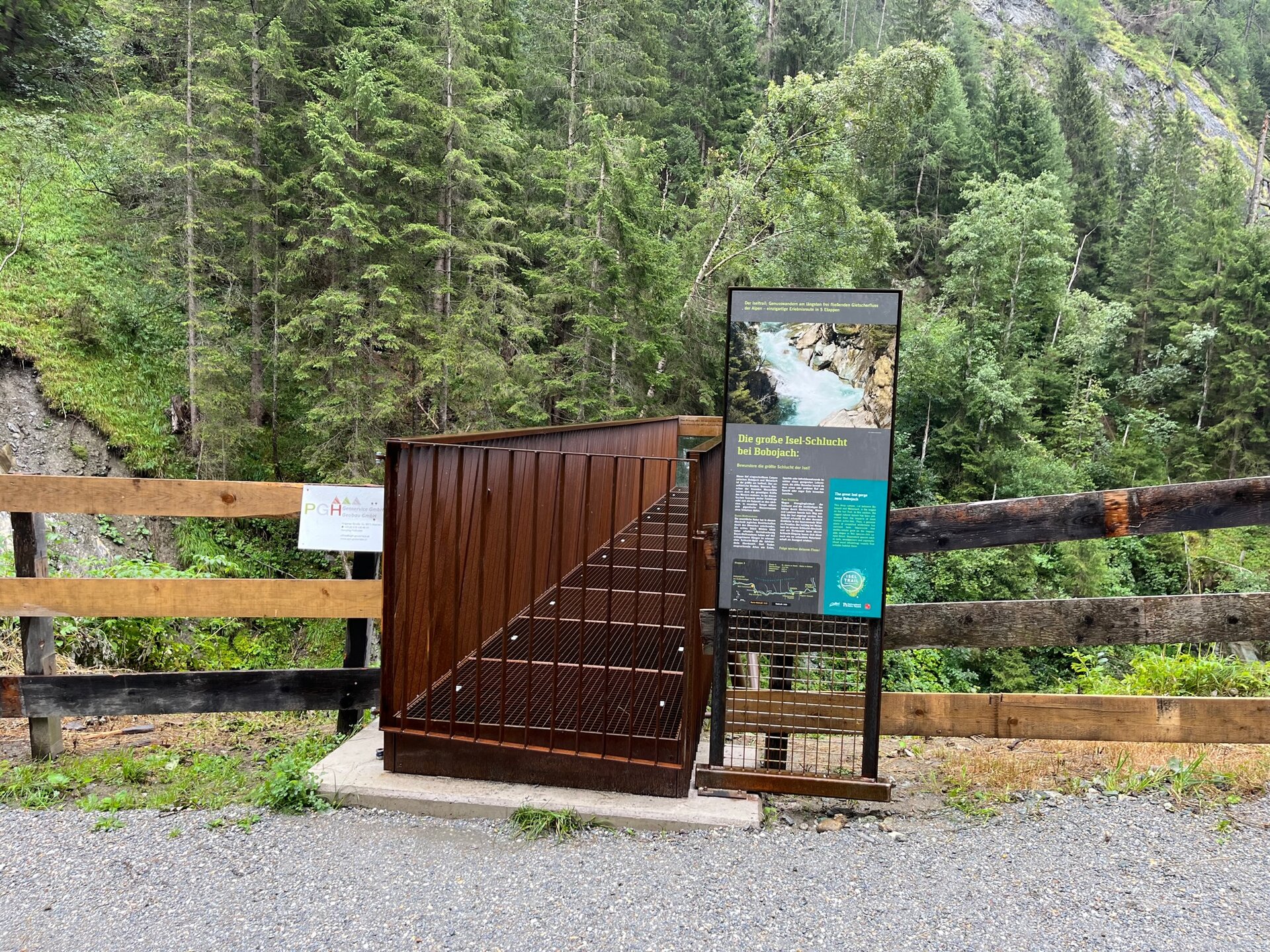
The Source of the Isel at the Umbalkees:
 

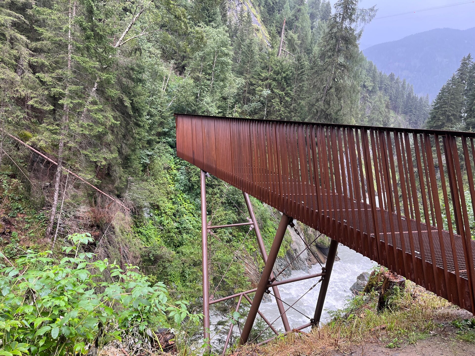
At first, the Iseltrail runs across wide alpine grasslands full of flowers. A steep scarp, which was covered by the glacier just a few decades ago, marks the beginning of the arctic climate zone of Hohe Tauern National Park. The source of the Isel is finally reached at the ice front of the Umbalkees below the mighty Dreiherrenspitze (3499m) – the highlight of the hike. Here the Isel leaves the huge ice stream in a constantly changing glacier mouth and via Drava and Danube heads towards the Black Sea.


Born in the snow

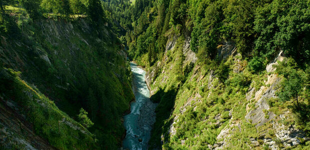
Glaciers are a strange world of ice, rubble, insidious crevasses and at first frequently torrential streams, but also of gracefully intertwined sandars – sandy areas with islands in the glacier foreland that are constantly changed by the water. Glaciers are born in the cold: under metres of snow masses in the highest areas, pressure transforms the snow crystals into granular firn, which is gradually compressed to ice. Its enormous weight makes the ice slide downwards slowly. If enough ice is added quick enough from above, glaciers can reach down into the valleys. 


Helpful water suppliers

No matter how threatening glaciers might appear, they also help people: In the upper glacier areas, the accumulation zone, they store water in the form of ice and release it again after many years in the ablation zone. Glaciers are gigantic water buffer storages that feed the rivers in summer with rain that fell in winter. 

This melt water supplied by the glaciers guarantees plenty of water in many large Alpine rivers, even in summer. In hot, dry summers, when almost all of the winter snow on the mountains disappears, particularly much melt water accrues. 


Glacial recession

Glaciers are therefore a kind of climate warning system: their recession is an indicator for global warming. The Umbalkees is also suffering from the climate crisis. The tongue of the Umbalkees has retreated by more than 700 metres since 1990 (glacial reports prepared by the OeAV/Austrian Alpine Association).


Climatologists assume that most glaciers in the Eastern Alps will have disappeared by the middle of the century. This does not only affect the beauty of the alpine mountains, it also has negative effects on the human world: if no melt water is supplied in summer, glacial rivers like the Isel will bring much less water into the lowlands. In addition, glaciers – together with the permafrost in the rock – stabilise the rock flanks. Slopes lose their stability due to the loss of glaciers, alpine dangers increase. And even the vegetation zones in the Alps are changing already: forests and alpine meadows are moving higher.


New, appealing setting

Due to climate change and the associated melting of the glaciers, a new landscape has formed and is still forming, which is also attractive in another way. The vegetation becomes barren, pioneer plants conquer inhospitable habitats of hardly earthy soil. The Iseltrail runs through this unique scenery to the glacier mouth, where the source of the Isel is located.

The stages of the Isel trail

Iseltrail

starting point:
Lienz
destination point:
Gletscherzunge am Umbalkees
highest point:
2500 m
total walking time
23 h
distance
73.7 km
🔋
altitude meters uphill
2120 hm
🞽
difficulty
average

Stages outline

The Isel trail is divided into sections of different lengths that each run between settlements with catering and accommodation possibilities. The Isel trail can therefore be pursued very flexibly – according to your mood, fitness level, need for recovery or enjoyment of striding ahead. In the following you can find a suggestion for 5 stages:

Iseltrail Stage 1

starting point:
Lienz
destination point:
St. Johann im Walde
highest point:
750 m
total walking time
4:30 h
distance
16.1 km
🔋
altitude meters uphill
80 hm
🞽
difficulty
average

Iseltrail Stage 2

starting point:
St. Johann im Walde
destination point:
Matrei in Osttirol
highest point:
968 m
total walking time
4 h
distance
14.5 km
🔋
altitude meters uphill
227 hm
🞽
difficulty
average

Iseltrail Stage 3

starting point:
Matrei in Osttirol
destination point:
Prägraten am Großvenediger
highest point:
1317 m
total walking time
5 h
distance
16.1 km
🔋
altitude meters uphill
556 hm
🞽
difficulty
average

Iseltrail Stage 4

starting point:
Prägraten am Großvenediger
destination point:
Clarahütte
highest point:
2040 m
total walking time
4:30 h
distance
11.3 km
🔋
altitude meters uphill
765 hm
🞽
difficulty
average

Iseltrail Stage 5

starting point:
Hut Clarahütte
destination point:
Glacier tongue at the Umbalkees
highest point:
2500 m
total walking time
6:30 h
distance
16.1 km
🔋
altitude meters uphill
475 hm
🞽
difficulty
difficult

Isel the natural wonder

Only few big rivers in the Alps can still flow freely today, unrestricted by dam walls. The Isel in Osttirol, alongside the Lech in North Tyrol and the Tagliamento in Friuli/Italy, is among these last major alpine wild rivers in Central Europe. Its water volume is not diverted anywhere for energy industry purposes or power plants. Along extensive stretches, the Isel therefore displays an unbridled and constantly changing riverbed with a special diversity of rare habitats and species, offering the unique nature experience.

youtube video

Pulsating artery of life

Contrary to the Lech and Tagliamento, the Isel is also a glacial river. It has its source at the Umbalkees glacier, high up in the wilderness of the Hohe Tauern National Park. From the glacier, it rushes as a pulsating artery of life of Osttirol down to its estuary into the Drau in Lienz. It thus links the expanse of alpine seclusion with the cultivated landscape in the valley basin.


Rare originality

With its tributaries, it forms a giant original waterway system. Its tributaries are also largely untouched, a guarantee for the purest water quality. A rarity in the landscape shaped intensely by people. The Isel is therefore the longest still free-flowing and therefore ecologically functional glacial river of the entire Alps.


Fluctuating water flow

Glacial rivers are different: their water flow fluctuates significantly depending on the time of day or the season, depending on the meltwater inflow from the glaciers in the catchment area. The water flow of glacial rivers in the summer months is determined by the glacial melt and displays a typical daily pattern: on a cool morning, a lot less water flows than in the evening, because the glacier melts less strongly. In the early afternoon, the incidence of sunshine on the glacier is the greatest, the ice melts away. In the case of the Isel, the meltwater reaches the valleys in the early evening and arrives during the night at the estuary of the Isel in Lienz.


Dynamic riverbed

In such as dynamic riverbed, floodwaters can flow around gravel masses and thereby create everchanging new islands, gravel bars and shore areas. This creates constantly new habitats that are then resettled. Specialists call this: pioneer sites. These are the condition for a series of rare flora and fauna, which have adapted to the constant change and need it for their continued existence.


The rare plant tamarisk

The German tamarisk (Myricaria germanica) is such a plant, the only one of its genre to exist in Central Europe. In the past, it was widespread by our rivers – every older botany book is witness to this. Today it is a rarity. As it needs a lot of light, but willow and alder trees easily overgrow it, it can only survive for the duration where new sand and gravel banks keep being created through the shifting activity of rivers.


Nature reserve as a flora-fauna habitat

The tamarisk is an unmistakable indication of the undisturbed dynamics and ecological functionality of a river. For these reasons, the Isel has been designated a nature reserve according to the Flora-Fauna-Habitat Directive of the EU. The tamarisks can be found especially in the lower Isel valley. Please appreciate the tamarisks from a respectful distance and do not step onto the gravel banks because of nesting birds!

The most important facts about the Isel

Source: Umbal glacier at altitude of 2600 m

Estuary: Drau in Lienz at altitude of 668 m

Altitude difference: 1932 metres

Total length: 57.26 km

Catchment area: 1200.36 km²

Proportion of natural/near-natural flow stretches: 100% 


Special fauna: sandpiper, grayling, grass frog, common toad, yellow-bellied toad, common otter, huchen

Special flora: German tamarisk

Important:

Take sun and rain protection, suitable mountain clothing (warm items) and sturdy footwear!

You may also be interested in

Debanttal
Schober trek

This alpine trek takes you to the most beautiful viewpoints of the Debant valley ...

Adlerweg Osttirol Etappe 2
Eagle Walk Osttirol

Walk where the eagle flies: discover the most beautiful connection between the highest mountains in Austria, in the middle of the National Park Hohe Tauern.

Newsletter

Subscribe to our newsletter and receive the best tips every month for current offers, mountain tours, events and much more.