Hiking in Defereggental

Intact natural landscape, unique wildlife.

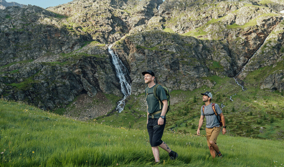
The Defereggental in Osttirol is a true diamond in the Nationalpark Hohe Tauern. The vacation region south of the Alps is proud of its intact, untouched natural landscape: lush meadows, fragrant stone pine forests, rustic alpine pastures and unique wildlife characterize the Defereggental. Here you can see golden eagles hunting and enjoy fresh alpine buttermilk.


Various themed trails invite you to get to know the alpine mountain world. Everyone will find something to suit them on the leisurely walks in the valley area, the varied routes in the Alpine pasture region and on summit climbs in the breathtaking world of the three-thousand-metre peaks.

back
Next
Etappe 3 - Wegweiser
Etappe 3 - Dorfberg Gipfelkreuz
Etappe 9 - Oberes Leitertal
Wandern Blickrichtung Großglockner
Zwei Männer wandern in Osttirols Bergen hinauf zum Geigensee durch hohes Bergwiesengras. Im Hintergrund ist ein kleiner Wasserfall zu sehen, der talwärts rinnt.

Due to its secluded location in the middle of the Nationalpark Hohe Tauern, Defereggental is influenced by an Alpine climate with Mediterranean influences - ideal for relaxing summer days in unspoiled nature. Defereggental is one of the most pristine high valleys in the Alps - a special landscape that impresses with its unique flora and fauna and a high degree of ecological responsibility. As a member of the "Austrian Mountaineering Villages", the valley consistently focuses on gentle tourism and the preservation of its natural and cultural identity. This attitude has already been recognized several times and makes Defereggental a model example of sustainable vacation experiences in the heart of Tyrol.

Alpengasthaus Obersee

Where the lake glistens, the peaks greet you and the path is the destination - the Alpengasthaus Obersee awaits you. Start your hike right on the doorstep and discover quiet paths, blooming alpine meadows and unforgettable views.

Theme trails

Themed path "In Apollo’s kingdom"

starting point:
Razell
destination point:
Rajach
highest point:
1720 m
total walking time
2 h
distance
4.3 km
🔋
altitude meters uphill
290 hm
🞽
difficulty
average

Nature and culture educational trail "Leben am Steilhang"

starting point:
Bruggen (St. Veit)
destination point:
Gassen
highest point:
1569 m
total walking time
3:30 h
distance
9.4 km
🔋
altitude meters uphill
440 hm
🞽
difficulty
average

Nature and culture educational trail "Oberhauser Zirbenwald"

starting point:
Alpengasthof Oberhaus
destination point:
Optional Verlänergung bis Jagdhausalmen
highest point:
1790 m
total walking time
40 min
distance
1.5 km
🔋
altitude meters uphill
20 hm
🞽
difficulty
easy

Themed Path “Alpenblumenweg Oberseite"

starting point:
St. Jakob/Trogach
destination point:
Seespitzhütte
highest point:
2367 m
total walking time
6 h
distance
14.1 km
🔋
altitude meters uphill
834 hm
🞽
difficulty
average

Hikes

easy hikes

Hike to Speikbodenhütte 2.050m

starting point:
Parkplatz
destination point:
Parkplatz St. Veit
highest point:
2050 m
total walking time
3:20 h
distance
5.37 km
🔋
altitude meters uphill
550 hm
🞽
difficulty
easy

Hike to Brunnalmstüberl

starting point:
Parkplatz Brunnalm
destination point:
Parkplatz Brunnalm
highest point:
2054 m
total walking time
3:40 h
distance
4.77 km
🔋
altitude meters uphill
652 hm
🞽
difficulty
easy

Hike to Trojeralm 1.810m

starting point:
Parkplatz Neue Mittelschule
destination point:
Parkplatz Neue Mittelschule
highest point:
1810 m
total walking time
3:30 h
distance
10.59 km
🔋
altitude meters uphill
433 hm
🞽
difficulty
easy

Circular hike to Staller Sattel

starting point:
Bushaltestelle Grünbichl
destination point:
Bushaltestelle Grünbichl
highest point:
2020 m
total walking time
1:20 h
distance
4.7 km
🔋
altitude meters uphill
70 hm
🞽
difficulty
easy

moderately difficult hikes

Speikboden 2.660m

starting point:
St. Veit Ort
destination point:
St. Veit Ort
highest point:
2653 m
total walking time
6 h
distance
17 km
🔋
altitude meters uphill
1190 hm
🞽
difficulty
average
state: closed

Hike to Brugger Alm 1.818m

starting point:
Parkplatz Brunnalm
destination point:
Parkplatz Brunnalm
highest point:
1818 m
total walking time
2:40 h
distance
6.9 km
🔋
altitude meters uphill
410 hm
🞽
difficulty
average

Großer Leppleskofel 2881 m

starting point:
Jausenstation Mooseralm
destination point:
Jausenstation Mooseralm
highest point:
2881 m
total walking time
2 h
distance
3.8 km
🔋
altitude meters uphill
440 hm
🞽
difficulty
average

Wetterkreuz 2.229m

starting point:
Junior high school St. Jakob
destination point:
Wetterkreuz
highest point:
2208 m
total walking time
5:30 h
distance
6 km
🔋
altitude meters uphill
820 hm
🞽
difficulty
average

difficult hikes

Regenstein 2.891m

highest point:
2891 m
total walking time
12 h
distance
9.6 km
🔋
altitude meters uphill
1772 hm
🞽
difficulty
difficult

Stanzling 2.716m

destination point:
Stanzling
highest point:
2662 m
total walking time
5:30 h
distance
6.5 km
🔋
altitude meters uphill
1100 hm
🞽
difficulty
difficult

Gösleswand 2.913m

starting point:
St. Jakob i. D.
destination point:
Gösleswand
highest point:
2912 m
total walking time
9:30 h
distance
25 km
🔋
altitude meters uphill
1510 hm
🞽
difficulty
difficult

Hochkreuz 2.739m

starting point:
Kapelle Maria Hilf
destination point:
Hochkreuz
highest point:
2739 m
total walking time
6:30 h
distance
17.5 km
🔋
altitude meters uphill
1300 hm
🞽
difficulty
difficult

Long-distance hiking trails

Embark on a journey on foot and get to know the mountains and valleys up close along various routes. The magnificent views, the fresh air, the exercise and the refreshments in huts, alpine pastures and inns - all of this combines to make long-distance hiking an unforgettable experience.


As a long-distance hiker, you not only embark on a search for yourself in Defereggental - you also learn to love the wild solitude of Osttirol.

Solder
2-TälerTrail: Hiking on the balcony of the Alps

A cross-border long-distance hiking trail in a panoramic mid-slope location in the Nationalpark Hohe Tauern.

Wasser
Lasörlingtreck - Three days trekking on the Lasörling

Experience wonderful days on the trekking tour in the Nationalpark Hohe Tauern. Good fitness and mountain equipment are essential for a successful trek.

Etappe 3 - Dorfberg Gipfelbuch Aufbewahrung
Hoch und Heilig - Bergpilgerweg

The "Hoch und Heilig - Bergpilgerweg" mountain pilgrimage trail stretches over 200 kilometers, divided into nine daily stages.

Bike & Hike

If you like hiking and want to discover new trails, combining it with a bike is an exciting addition. On so-called Bike & Hike tours, the first part of the route is covered by bike - usually up to a hut, mountain pasture or the head of a valley - before continuing on foot up to higher altitudes. This form of touring not only saves time and energy, but also opens up completely new opportunities to reach more remote peaks and scenic highlights.

This might also interest you

Zwei Personen auf E-Mountainbikes auf einem breiten Weg am Klaunzerberg. Im Hintergrund erstreckt sich das Tal und die umliegende Berglandschaft.
Biking in Defereggen

When cycling around Defereggen, you will discover the original side of the Alps: on quiet paths and gentle climbs, you will pass through...

Luftaufnahme der Burg Heinfels im Sommer.
Sights and excursion destinations

Osttirol offers a wide range of interesting excursion destinations and sights. The range extends from...

read more
Newsletter

Subscribe to our newsletter and receive the best tips every month for current offers, mountain tours, events and much more.