The most beautiful ski tours for experts

5 ski tours in the snowy Osttirol summit world.

"There are many paths to happiness. One is to spend a lot of time in the snowy mountains." The stranger to whom this quote is attributed is or was presumably an enthusiastic ski tourer. Perhaps someone who appreciates challenging routes. There are plenty of them in Osttirol. We present five tours that will make experienced "trackers" rejoice. Sweat-inducing climbs, sweeping descents, beautiful views - high-five with heart and brain in Villgratental, Defereggental, Kals am Großglockner, the Carnic Alps or the Lienzer Dolomites.


A look at the interactive map of Osttirol is recommended for all ski touring fans. There's nothing here that doesn't exist for friends of the quiet enjoyment of skiing. Easy ski tours for beginners, racy tours for experts. In the Osttirol mountains you will find what many are looking for: silence. Balm for the soul.


back
Next
Rewarding moments for sweat-inducing climbs
Sunset at the Bösen Weibl
"Berg Heil"
Summit happiness on the Bösen Weibl in Kals
Space & room in East Tyrol's mountains
Here you will find what many are looking for: silence. Balm for the soul.
The world is your oyster
View of the Venediger group
Past the ice giants of bygone times
Ascent on the Maurerkees
Are you looking for peace and relaxation away from mass tourism?
Osttirol will delight you with its untouched landscape and wild romance

Safety first

Safety is the be-all and end-all. Especially for the ski tours we present here. Are the weather conditions right? What avalanche warning level applies? What equipment (ABS backpack, avalanche transceiver, probe, shovel, first aid kit, cell phone) do you take with you? Do you know the risks in open terrain, can you adapt routes to current conditions, are you in good physical shape and can you master perfect turns in deep snow? Are you adept at using all the important equipment? Do you know what to do when things get dangerous? If you are unsure about the answers to these questions and still want to experience pure winter, then call on an experienced mountain and ski guide! Then nothing stands in the way of a ski tour on all "skins"!

5 ski tours for experts

Five routes that could hardly be more different. But they all have one thing in common: the tranquillity of the snow-covered Osttirol summits.

youtube video

Hochgrabe - the royal tour in the Villgrater mountains

Villgratental, 1,390 m ascent 6.5 h, 6 km, difficult

Tourers have always loved the Königstour on the Hochgrabe in the Villgratental. It is a real highlight. At 2,951 meters, the Hochgrabe is the third highest peak in the region. The tour starts at the Höggerhöfe ski touring parking lot in Innervillgraten. The route follows a forest path through the Einattal valley, past the Taletalm and Schmidhoferalm. At the Hochgrabe junction (sign), turn left up over steep grassy slopes. The snow-covered "Schupfen" are a popular photo motif. Just like the Seven Lakes, but only in summer. Then they glisten green-blue in the sun. In winter, they are covered in a thick blanket of snow. Climb the last slopes in sharp hairpin bends to the summit ridge and from there to the summit. At the top, take a deep breath, stop for a drink and look at the mountain summit: The LienzerDolomites, the Sesto Dolomites and, of course, the Villgrater mountains. The swift descent is either along the ascent route or via the Winkeltal valley.

Hochgrabe

starting point:
Innervillgraten, Ainettal
destination point:
Hochgrabe
🔋
altitude meters uphill
1390 hm
walking time uphill
6:30 h
distance
6.6 km

Great Kinigat - a reminder of peace with an impressive view

Carnic ridge 1,190 m elevation gain, 4h30, 7.5 km, difficult

Every ski tourer who sees the mighty north face of the Großer Kinigat is amazed and asks themselves respectfully - should I go up there on skis? The tour starts at Kartitscher Sattel and initially runs along the cross-country ski trail towards Obertilliach and later branches off to Schöntalsee. Following the ski tracks, the route continues over a steep slope to Weitenstall. Just above the Filmoor-Standschützenhütte hut, the view of the imposing south side of the Kinigat becomes clear. A short time later, you tackle a narrow ramp - but only in good snow and weather conditions. It is a sure-footed climb up to the highest point at 2,689 meters with gigantic views of the Carnic ridge and Dolomites. Peaceful silence. You can only guess that this was the scene of fierce fighting during the First World War. The European cross therefore serves as a reminder of understanding and peace. The rapid descent first takes you down the narrow summit ramp and then along the ascent track. Here, every ski tourer can live out their passion as an experienced skier .

Große Kinigat

starting point:
Kartitscher Sattel
destination point:
Große Kinigat
🔋
altitude meters uphill
1190 hm
walking time uphill
4:30 h
distance
7.5 km

Karlsbader Schartenschartl - a real treat in the Lienzer Dolomites

Lienzer Dolomiten 1.490 HM, 4h30, 8km, difficult

The Lienzer Dolomiten are a comparatively small mountain range that entices with adventurous ski tours. Where else can you climb up through a rocky gully? But first things first: the tour starts at Gasthaus Kreithof, south-east of the municipality of Tristach. Off you go across snow-covered meadows to the Dolomitenhütte. There you can already see the rugged rock faces towering upwards. Into the Laserzkessel. Shortly after the Instein-Alm (1,680 m), the route leads through mountain pine fields to the Marcher Stein. The gliding passage to the Karlsbader Hütte provides relaxation and enjoyment. Just a stone's throw away to the east, you take the sunny flanks with an incline of no less than 30 degrees. The Große Sandspitze looms above you and, somewhat hidden, you will find the narrow gully of the Schartenschartl at an altitude of around 2,500 meters. Breathing heavily and sweating, you climb the last 170 meters of altitude. Shouldering your skis or using the hairpin technique. Just one more sharp cut (35 degrees) between Kleiner Sandspitze and Lavanter Gamswiesenspitze, then it's done. Take particular care here in fresh snow, as there is an increased risk of avalanches. Surrounded by the wild and striking peaks and pinnacles of the Lienzer Dolomites, this tour is a real treat.

Karlsbaderhütte - Schartenschartl

starting point:
Tristach / Kreithof
destination point:
Schartenschartl
🔋
altitude meters uphill
1490 hm
walking time uphill
4:30 h
distance
8 km

Böses Weibl - Enchanting tour at the foot of the Großglockner

Hohe Tauern 1,210 HM, 4h, 6.5km, difficult

The cone-shaped summit alone is worth seeing. The Böse Weibl is certainly one of the most popular ski tours, starting at the Lucknerhaus above Kals. A cart track leads uphill to the Niggl Alm. From here, hairpin bends are required as you head over a forest ridge to Peischlachtörl. The ascent track tends to remain at medium altitude. The area is predestined for avalanches. Before the summit of the Böses Weibl (3,119m), the route leads to the Tschadinsattel in several strenuous hairpin bends. Down through a small depression and the last few meters to the summit without skis. Osttirol and the Nationalpark Hohe Tauern lie at your feet. And why is the cone now called Böses Weibl? Presumably because severe thunderstorms repeatedly erupt on the mountain. In earlier times, people in the valley attributed these capers to witches, i.e. "evil women". You have never met one here. Although the mountain has everything to enchant. Incidentally, this also applies to the descent via the Lesachtal valley. If you don't want to descend via the ascent track and are an experienced skier, you can ski down from 3,000m to Lesach at 1,300m above sea level in good conditions.

Böses Weibl 3.119m

starting point:
Kals / Lucknerhaus
destination point:
Böses Weibl
🔋
altitude meters uphill
1210 hm
walking time uphill
4 h
distance
6.5 km

Almerhorn and Hochgall - On skis in the Rieserferner Group

Defereggental 1650 HM, 7-8h, 8,2km difficult

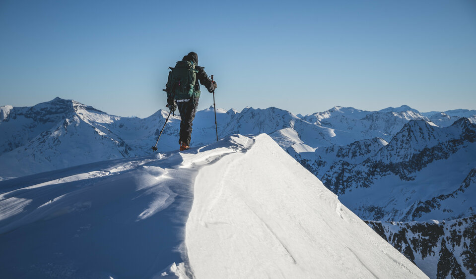
First of all: the tour to the summit of Hochgall and/or Almerhorn in Defereggental is hard work. But the summit view of the Rieserferner group and far into the Sesto and Lienzer Dolomites is worth every drop of sweat on the ascent. The tour works best in spring when the snow conditions are stable. The starting point is the parking lot at the Staller Sattel in St. Jakob. First over a former ski slope, later over snow-covered, moderately steep terrain to the foot of the Jägerscharte. Take a breather, drink, look around. Because now comes the first difficult section. Up to 45 degrees steep and overgrown in some places. Up to the Jägerscharte at 2,860 meters. If there is little snow, you can set up a ski depot at the saddle and cover the last few meters on foot. There are a few more hairpin bends to cover on skis before you reach the summit cross of the Almerhorn (2,985 m) in soothing silence. The neighboring summit within sight is a completely different story. The imposing Hochgall (3,436m), which is hugely popular with ski tourers, is busier. This giant of ice and rock can - if you are in good physical condition - serve as an extension of the previously described tour. From the Jägerscharte, the route first descends in a north-westerly direction to the lonely Barmer Hütte. On the ground below the hut, you climb up to the Riepenscharte and on to the Patscherkees. From there, it is comparatively easy to access the Hochgall gully, which has a steepness of up to 42 degrees and leads to the winter summit via the narrow north-east ridge. The reward: the view and the challenging descent through the gully. But only with the best skiing technique and in the best conditions. If you prefer, you can also skate down through the Patschertal valley and along the road to Erlsbach. But then you will need a second car to get back to the starting point.

Hochgall 3.436m

starting point:
Staller Sattel (2.000 m)
destination point:
Hochgall (3.436 m)
🔋
altitude meters uphill
1570 hm
walking time uphill
6 h
distance
7.3 km
Newsletter

Subscribe to our newsletter and receive the best tips every month for current offers, mountain tours, events and much more.