Ski tours around Obertilliach

Be inspired by the impressive mountain scenery

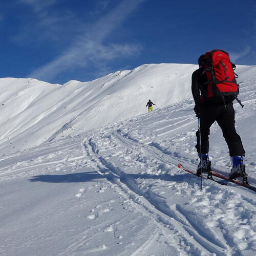
Ski tours in Obertilliach take you to plateaus and mountains up to almost 2600 m above sea level. Inspired by the impressive mountain scenery, you can admire the positions left over from the First World War, the picturesque alpine pastures and Schupfen around Obertilliach and the bizarre rock formations of the Lienzer Dolomiten and South Tyrolean Dolomites in the distance.

filter results
more filter otions
starting point:
Hinterbichl parking spot Wiesenkreuz
destination point:
Großvenediger 3.657 m
🔋
altitude meters uphill
2168 hm
walking time uphill
7 h
distance
13.3 km
starting point:
Essener-Rostocker Hütte 2.208m
destination point:
Mittl. Malhamspitze 3.360m
🔋
altitude meters uphill
1980 hm
walking time uphill
6 h
distance
11.8 km
starting point:
Car park Welzelach
destination point:
Berger Kogel 2.656m
🔋
altitude meters uphill
1288 hm
walking time uphill
4 h
distance
6.3 km
starting point:
Car park chapel Wallhorn 1.400 m
destination point:
Weißspitze 3.300 m
🔋
altitude meters uphill
1880 hm
walking time uphill
6 h
distance
9.1 km
starting point:
Car park Wallhorn chapel 1.450m
destination point:
Wunalm 2.341m
🔋
altitude meters uphill
915 hm
walking time uphill
2:30 h
distance
3.3 km
starting point:
Kals / Lucknerhaus
destination point:
Glorerhütte (2651 m)
🔋
altitude meters uphill
720 hm
walking time uphill
2:30 h
distance
4.3 km
starting point:
St. Jakob i. Def. / Staller Sattel
destination point:
Kauschkahorn (2.903 m)
🔋
altitude meters uphill
1170 hm
walking time uphill
3:30 h
distance
4.9 km
starting point:
Felbertauern / Südportal
destination point:
Amertaler Höhe (2.841 m)
🔋
altitude meters uphill
1211 hm
walking time uphill
4 h
distance
5 km
starting point:
Staller Sattel
destination point:
Rote Wand (2.818 m)
🔋
altitude meters uphill
800 hm
walking time uphill
3 h
distance
6 km
starting point:
St. Jakob i. Def. / Staller Sattel
destination point:
Almerhorn
🔋
altitude meters uphill
980 hm
walking time uphill
3 h
distance
3.6 km
starting point:
Kartitscher Sattel
destination point:
Dorfberg, Golzentipp
🔋
altitude meters uphill
910 hm
walking time uphill
4 h
distance
12 km
starting point:
Lienz / Zettersfeld Centre
destination point:
Goisele
🔋
altitude meters uphill
1200 hm
walking time uphill
5 h
distance
8.1 km
starting point:
Iselsberg / Penzelberg
destination point:
Strasskopf
🔋
altitude meters uphill
1030 hm
walking time uphill
4 h
distance
6.8 km
starting point:
Kartitsch / Rauchenbach
destination point:
Öfenspitze
🔋
altitude meters uphill
820 hm
walking time uphill
2:30 h
distance
5 km
starting point:
Außervillgraten / Winkeltal
destination point:
Gölbner
🔋
altitude meters uphill
1370 hm
walking time uphill
6 h
distance
6.3 km
starting point:
Innervillgraten, Ainettal
destination point:
Hochgrabe
🔋
altitude meters uphill
1390 hm
walking time uphill
6:30 h
distance
6.6 km
starting point:
Innervillgraten, Kalkstein
destination point:
Marchkinkele
🔋
altitude meters uphill
900 hm
walking time uphill
3 h
distance
3.6 km
starting point:
Innervillgraten, Schettlet
destination point:
Rotes Kinkele
🔋
altitude meters uphill
1050 hm
walking time uphill
4 h
distance
4.6 km
starting point:
Innervillgraten, Kalkstein
destination point:
Pürglers Kunke
🔋
altitude meters uphill
860 hm
walking time uphill
3 h
distance
3.7 km
starting point:
Innervillgraten, Kalkstein
destination point:
Kreuzspitze
🔋
altitude meters uphill
1000 hm
walking time uphill
3 h
distance
4.7 km
starting point:
Felbertauernstraße / Car park Landeckwald
destination point:
Wilde Mander Scharte 2.615m
🔋
altitude meters uphill
1143 hm
walking time uphill
3:30 h
distance
4.3 km
starting point:
Car park Ströden 1.400m
destination point:
Westliche Simonyspitze 3.481m
🔋
altitude meters uphill
2010 hm
walking time uphill
7 h
distance
13.6 km
starting point:
Matreier Tauernhaus
destination point:
Weißeneckscharte 2.637m
🔋
altitude meters uphill
1116 hm
walking time uphill
3:30 h
distance
6.1 km
starting point:
Car park Wiesenkreuz 1.490m
destination point:
Tulpspitze 3.054m
🔋
altitude meters uphill
1562 hm
walking time uphill
5 h
distance
7.3 km
starting point:
Assling / Bichl
destination point:
Tullnkogel
🔋
altitude meters uphill
1000 hm
walking time uphill
3:30 h
distance
5.6 km
starting point:
Heinfels / Tessenberg
destination point:
Tessenberger Alm
🔋
altitude meters uphill
920 hm
walking time uphill
2 h
distance
7.3 km
starting point:
Iselsberg / Stronach
destination point:
Stronachkogel
🔋
altitude meters uphill
710 hm
walking time uphill
2 h
distance
3.1 km
starting point:
Wallhorn / Prägraten
destination point:
Seeköpfe
🔋
altitude meters uphill
1820 hm
walking time uphill
6 h
distance
8.3 km
starting point:
Ski area Zettersfeld
destination point:
Schleinitz
🔋
altitude meters uphill
970 hm
walking time uphill
3:50 h
distance
4.8 km
starting point:
Thurn / Bridge Zauchenbach
destination point:
Rotgebele
🔋
altitude meters uphill
1300 hm
walking time uphill
4 h
distance
4.36 km
starting point:
Matreier Tauernhaus
destination point:
Rote Säule/Rote Saile
🔋
altitude meters uphill
1289 hm
walking time uphill
5 h
distance
4.2 km
starting point:
Obertilliach / Aue
destination point:
Reiterkarspitze
🔋
altitude meters uphill
1170 hm
walking time uphill
4 h
distance
6.3 km
starting point:
St. Jakob i. Def. / Innerberg
destination point:
Langschneid
🔋
altitude meters uphill
1230 hm
walking time uphill
5 h
distance
5.6 km
starting point:
Kartitscher Sattel
destination point:
Große Kinigat
🔋
altitude meters uphill
1190 hm
walking time uphill
4:30 h
distance
7.5 km
starting point:
Tristach / Kreithof
destination point:
Schartenschartl
🔋
altitude meters uphill
1490 hm
walking time uphill
4:30 h
distance
8 km
starting point:
Tristach / Kreithof
destination point:
Ödkarscharte
🔋
altitude meters uphill
1550 hm
walking time uphill
4:30 h
distance
8.1 km
starting point:
Staller Sattel
destination point:
Innerrodelkunke
🔋
altitude meters uphill
720 hm
walking time uphill
2:30 h
distance
3.6 km
starting point:
Kals / Taurerwirt
destination point:
Hochtor
🔋
altitude meters uphill
970 hm
walking time uphill
3 h
distance
4.3 km
starting point:
Obertilliach / Soldhäuser
destination point:
Hochspitz
🔋
altitude meters uphill
1320 hm
walking time uphill
4:30 h
distance
6.2 km
starting point:
Fraktion Lesach / Kals
destination point:
Hochschober
🔋
altitude meters uphill
1795 hm
walking time uphill
6 h
distance
8.1 km
starting point:
Felbertauern South portal
destination point:
Hochgasser 2.922m
🔋
altitude meters uphill
1240 hm
walking time uphill
4 h
distance
4.5 km
starting point:
St. Jakob i. Def. / Staller Sattel
destination point:
Hinterbergerkofel
🔋
altitude meters uphill
730 hm
walking time uphill
3 h
distance
3.8 km
starting point:
Gondelbahn Golzentipp
destination point:
(2.317 m)
🔋
altitude meters uphill
860 hm
walking time uphill
2:45 h
distance
3.6 km
state: closed
starting point:
Hopfgarten i. Def. bei der überdachten Holzbrücke am Ortsende
destination point:
Gagen im Zwenewaldtal
🔋
altitude meters uphill
1310 hm
walking time uphill
4 h
distance
7 km
starting point:
Kalser Großglocknerstraße
destination point:
Figerhorn
🔋
altitude meters uphill
870 hm
walking time uphill
2:30 h
distance
3.1 km
starting point:
Kals / Lucknerhaus
destination point:
Böses Weibl
🔋
altitude meters uphill
1210 hm
walking time uphill
4 h
distance
6.5 km
starting point:
Tristach / Kreithof
destination point:
Auerlingköpfl
🔋
altitude meters uphill
974 hm
walking time uphill
3 h
distance
4.8 km
starting point:
Innervillgraten / Kalkstein (1.640 m)
destination point:
Gaishörndl (2.615 m)
🔋
altitude meters uphill
975 hm
walking time uphill
3:30 h
distance
4.6 km
starting point:
Innervillgraten / Kalkstein (1.640 m)
destination point:
Toblacher Pfannhorn (2.663 m)
🔋
altitude meters uphill
1010 hm
walking time uphill
3:50 h
distance
5 km
starting point:
Innervillgraten / Unterstaller Alm (1.653 m)
destination point:
Degenhorn (2.946 m)
🔋
altitude meters uphill
1450 hm
walking time uphill
6:30 h
distance
10.6 km
starting point:
Innervillgraten / Parkplatz unterhalb der "Höggerhöfe" (1.560 m)
destination point:
Hohes Haus (2.784 m)
🔋
altitude meters uphill
1350 hm
walking time uphill
5 h
distance
6.7 km
starting point:
Außervillgraten / Niederbruggeralm (1.600 m)
destination point:
Hochgrabe (2.951 m)
🔋
altitude meters uphill
1430 hm
walking time uphill
6 h
distance
12.2 km
starting point:
Außervillgraten / Niederbruggeralm (1.600 m)
destination point:
Regenstein (2.891 m)
🔋
altitude meters uphill
1285 hm
walking time uphill
5 h
distance
6.6 km
starting point:
Außervillgraten / kleiner Parkplatz beim Weiler Oberwurzen (1.700 m)
destination point:
Gabesitten (2.665 m)
🔋
altitude meters uphill
970 hm
walking time uphill
4:30 h
distance
4.1 km
starting point:
Obertilliach / Biathlonzentrum (1.400 m)
destination point:
Hoher Bösring (2.324 m)
🔋
altitude meters uphill
950 hm
walking time uphill
3 h
distance
4.6 km
starting point:
Obertilliach / Ortsteil Bergen, Goller Säge (1.270 m)
destination point:
Spitzköfele
🔋
altitude meters uphill
1100 hm
walking time uphill
4 h
starting point:
St. Jakob i. D. / Tögisch 1.610 m
destination point:
Gasser Horn 2.612m
🔋
altitude meters uphill
950 hm
walking time uphill
3 h
distance
2.4 km
starting point:
St. Jakob i. Def. / Maria Hilf, Rinderschinken (1420 m)
destination point:
Hochkreuz
🔋
altitude meters uphill
1190 hm
walking time uphill
4 h
distance
8 km
starting point:
Kals / Taurerwirt (1.490 m)
destination point:
Graue Scharte (2.980 m)
🔋
altitude meters uphill
1492 hm
walking time uphill
5 h
distance
4 km
starting point:
Virgen/Obermauern/car park Budam
destination point:
Bonn-Matreier-Hütte 2.750m
🔋
altitude meters uphill
1273 hm
walking time uphill
3:50 h
distance
6 km
starting point:
Prägraten a. G. / Ströden 1.403 m
destination point:
Großer Geiger 3.360m
🔋
altitude meters uphill
1945 hm
walking time uphill
6 h
distance
10.6 km
starting point:
Tristach – Kreithof (1.050 m)
destination point:
Schöttnerspitze (2.633 m)
🔋
altitude meters uphill
1550 hm
walking time uphill
4:50 h
distance
7.4 km
starting point:
Kals – Oberlesach (1.415 m)
destination point:
Kalser Törl (2.809 m)
🔋
altitude meters uphill
1180 hm
distance
6 km
starting point:
Kals – Lucknerhaus (1.920 m)
destination point:
Gridenkarköpfe (3.031 m)
🔋
altitude meters uphill
1040 hm
walking time uphill
3:50 h
distance
12.7 km
starting point:
Oberassling/Warscherhof (1.510 m)
destination point:
Mundsalspitze (2.682 m)
🔋
altitude meters uphill
1170 hm
walking time uphill
3:50 h
distance
7.3 km
starting point:
Anras / Goll (1.300 m)
destination point:
Gumriaul (2.918 m)
🔋
altitude meters uphill
1450 hm
walking time uphill
4 h
distance
8.4 km
starting point:
Hollbruck (1.360 m)
destination point:
Hollbrucker Spitze (2.581 m)
🔋
altitude meters uphill
1220 hm
walking time uphill
4 h
distance
6 km
starting point:
St. Veit i. Def. – Oberholz 1.660 m
destination point:
Speikboden (2.653 m)
🔋
altitude meters uphill
990 hm
walking time uphill
3 h
distance
3.9 km
starting point:
St. Jakob (1.400 m)/Tögisch (1.653 m)
destination point:
Prägratner Törl (2.846 m)
🔋
altitude meters uphill
1180 hm
walking time uphill
4 h
distance
5.6 km
starting point:
St. Jakob – Innerberg (1.700 m)
destination point:
Seespitze (3.021 m)
🔋
altitude meters uphill
1320 hm
walking time uphill
4 h
distance
5.2 km
starting point:
St. Jakob – Staller Sattel Straße (1.837 m)
destination point:
Deferegger Pfannhorn (2.820 m)
🔋
altitude meters uphill
810 hm
walking time uphill
3:50 h
distance
3.8 km
starting point:
Car park Welzelach 1.150m
destination point:
Lasörling 3.098 m
🔋
altitude meters uphill
1950 hm
walking time uphill
6 h
distance
10.7 km
starting point:
Tristach/Kreithof (1.050 m)
destination point:
Grubenspitze (2.671 m)
🔋
altitude meters uphill
2300 hm
walking time uphill
6 h
distance
8.7 km
starting point:
Debanttal – "Säge"
destination point:
Debantgrat (3.052 m)
🔋
altitude meters uphill
1600 hm
walking time uphill
7:30 h
distance
15.2 km
starting point:
Kartitsch/Sportplatz (1.415 m)
destination point:
Pfannspitze (2.678 m)
🔋
altitude meters uphill
1250 hm
walking time uphill
4:50 h
distance
6.1 km
starting point:
Kartitsch/Sportplatz (1.415 m)
destination point:
Eisenreich (2.655 m)
🔋
altitude meters uphill
1240 hm
walking time uphill
4:50 h
distance
4.9 km
starting point:
Kartitsch/Sportplatz (1.415 m)
destination point:
Gatterspitze (2.430 m)
🔋
altitude meters uphill
880 hm
walking time uphill
3:50 h
distance
4.9 km
starting point:
St. Veit i. Def./Oberholz (1.660 m)
destination point:
Mullitz Kopf (2.736 m)
🔋
altitude meters uphill
1060 hm
walking time uphill
3 h
distance
4.1 km
starting point:
St. Jakob im Def./Maria Hilf, Ortsteil Rinderschinken (1.520 m)
destination point:
Kahorn (2.692 m)
🔋
altitude meters uphill
1150 hm
walking time uphill
3 h
distance
6.5 km
starting point:
Matrei - Felbertauernstraße/Landecktal (1.380 m)
destination point:
Kalser Bärenkogel Nordwestgipfel (3.034 m)
🔋
altitude meters uphill
1513 hm
walking time uphill
5 h
distance
8.3 km
starting point:
Kals/Oberlesach 1.415 m
destination point:
Schobertörl (
🔋
altitude meters uphill
1529 hm
walking time uphill
4:30 h
distance
7.2 km
starting point:
Dölsach / chapel in Görtschach 800m
destination point:
Ederplan (2061
🔋
altitude meters uphill
1260 hm
walking time uphill
3:50 h
distance
8.2 km
starting point:
Iselsberg / Penzelberg (1.375 m)
destination point:
Strassboden (2.401 m)
🔋
altitude meters uphill
1000 hm
walking time uphill
4 h
distance
7.3 km
starting point:
Oberdrauburg – Oberpirkach (630 m)
destination point:
Hochstadel (2.681 m)
🔋
altitude meters uphill
2050 hm
walking time uphill
6 h
distance
10.9 km
starting point:
Kals / Lucknerhaus (1.920 m)
destination point:
Großglockner (3798 m9
🔋
altitude meters uphill
2830 hm
walking time uphill
10 h
distance
20 km
starting point:
Staller Sattel (2.000 m)
destination point:
Hochgall (3.436 m)
🔋
altitude meters uphill
1570 hm
walking time uphill
6 h
distance
7.3 km
starting point:
Sillian (1.100 m)
destination point:
Helm (2.550 m)
🔋
altitude meters uphill
1450 hm
walking time uphill
4 h
starting point:
Schlaiten/Straße Richtung Glanz (995 m)
destination point:
Schönberglspitze (2.640 m)
🔋
altitude meters uphill
1640 hm
walking time uphill
5 h
distance
5.9 km
starting point:
Matreier Tauernhaus
destination point:
Wildenkogel 3.021 m
🔋
altitude meters uphill
1350 hm
walking time uphill
4 h
distance
4.2 km
starting point:
Matreier Tauernhaus 1.512 m
destination point:
Äußerer Knorrkogel 2.921 m
🔋
altitude meters uphill
1400 hm
walking time uphill
5 h
distance
10.3 km
starting point:
St. Jakob i. Def./Skizentrum St. Jakob i. Def. (2.373 m)
destination point:
Großer Leppleskofel (2.811 m)
🔋
altitude meters uphill
1390 hm
walking time uphill
3 h
distance
6.2 km
starting point:
Kasern / Südtirol
destination point:
Kals am Großglockner
🔋
altitude meters uphill
9230 hm
distance
92 km
starting point:
Parkplatz Oberlesach
destination point:
Lesach Riegel
🔋
altitude meters uphill
710 hm
walking time uphill
2:30 h
distance
5.6 km
starting point:
Parkplatz Glocknerwinkel
destination point:
Stüdlhütte
🔋
altitude meters uphill
880 hm
walking time uphill
3 h
distance
4.8 km
starting point:
Parkplatz Glocknerwinkel
destination point:
Romariswandkopf
🔋
altitude meters uphill
1550 hm
walking time uphill
5:30 h
distance
8.8 km
starting point:
Parkplatz Glocknerwinkel
destination point:
Weißer Knoten
🔋
altitude meters uphill
960 hm
walking time uphill
3 h
distance
8.2 km
starting point:
Parkplatz Dorfertal
destination point:
Brunnerkogel
🔋
altitude meters uphill
1090 hm
walking time uphill
3 h
distance
8.2 km
starting point:
Assling / Bichl
destination point:
Ski hut Compedal
🔋
altitude meters uphill
390 hm
walking time uphill
1:30 h
distance
2.1 km
starting point:
Parkplatz Glocknerwinkel
destination point:
Burgwartscharte
🔋
altitude meters uphill
1430 hm
walking time uphill
4 h
distance
15 km
starting point:
Parkplatz Oberlesach
destination point:
Parkplatz Oberlesach
🔋
altitude meters uphill
1584 hm
walking time uphill
5 h
distance
5.9 km
starting point:
Parkplatz Högger
destination point:
Käseberg
🔋
altitude meters uphill
1020 hm
walking time uphill
3:30 h
distance
5.5 km
starting point:
Innervillgraten / Kalkstein
destination point:
Kalksteiner Jöchl
🔋
altitude meters uphill
860 hm
walking time uphill
3:30 h
distance
5 km
🔋
altitude meters uphill
910 hm
walking time uphill
3:30 h
distance
4.6 km
starting point:
Parkplatz Lüfter
destination point:
Riepenspitze
🔋
altitude meters uphill
1300 hm
walking time uphill
6:30 h
distance
8.5 km
starting point:
Parkplatz Fürathöfe
destination point:
Öwelenke
🔋
altitude meters uphill
870 hm
walking time uphill
2:30 h
distance
4.3 km
starting point:
Innervillgraten / Tischlerei Lanser
destination point:
Marchkinkele
🔋
altitude meters uphill
1190 hm
walking time uphill
4 h
distance
6.7 km
starting point:
Parkplatz Fürathöfe
destination point:
Hochstein
🔋
altitude meters uphill
1140 hm
walking time uphill
3:30 h
distance
5.7 km
starting point:
Parkplatz Reiterstube
destination point:
Hochalmspitze
🔋
altitude meters uphill
1200 hm
walking time uphill
5:30 h
distance
7.6 km
starting point:
Reiterstube Außervillgraten
destination point:
Grabenstein
🔋
altitude meters uphill
1060 hm
walking time uphill
3:30 h
distance
5.9 km
starting point:
valley station chairlift Steinermandl
destination point:
Schoberköpfl
🔋
altitude meters uphill
440 hm
walking time uphill
1:50 h
distance
2.7 km
starting point:
Valley station Faschingalm
destination point:
Mountain station Steinermandl
🔋
altitude meters uphill
510 hm
walking time uphill
2 h
distance
3.1 km
starting point:
Skilift station Faschingalm
destination point:
Mountain station Steinermandl
🔋
altitude meters uphill
540 hm
walking time uphill
2:10 h
distance
2.9 km
starting point:
Tristach / Kreithof
destination point:
Dolomitenhütte
🔋
altitude meters uphill
600 hm
walking time uphill
1:30 h
distance
3.3 km
starting point:
St. Oswald
destination point:
Dorfberg
🔋
altitude meters uphill
740 hm
walking time uphill
2:30 h
distance
6.6 km
starting point:
Hinterbichl / Ströden
destination point:
Lucknerhaus
🔋
altitude meters uphill
10112 hm
distance
110.5 km
starting point:
Almfamilyhotel beim Himbeergoll-Lift
destination point:
Golzentipp
🔋
altitude meters uphill
850 hm
walking time uphill
2:30 h
distance
3.9 km
state: closed
starting point:
Almfamilyhotel beim Himbeergoll-Lift
destination point:
Golzentipp
🔋
altitude meters uphill
860 hm
walking time uphill
3 h
distance
5 km
starting point:
Flatsch im Ortsteil Bergen
destination point:
Steinrastl 2.184 m
🔋
altitude meters uphill
715 hm
walking time uphill
2:30 h
distance
3.4 km
starting point:
Freizeitzentrum Gries
destination point:
Lasörling 3.098m
🔋
altitude meters uphill
1801 hm
walking time uphill
5:30 h
distance
9.9 km
starting point:
Car park Wallhorn chapel 1.400m
destination point:
Seewandkopf 3.024m
🔋
altitude meters uphill
1610 hm
walking time uphill
5:30 h
distance
7.64 km
scroll for more

A ski tour combines a sporting challenge, impressive nature experiences and the thrill of adventure. In his "House Touren Booklet", renowned American alpinist Steve House not only provides inspiring tour suggestions for every level of difficulty, but also explains what is important for the perfect ski tour.


Careful planning, a look at the weather forecast and an analysis of the avalanche report are essential to minimize risks and make the tour safe. The current avalanche situation can be called up directly at lawinen.report - a must before every ski tour.

Insider tips in the Osttirol Blog

Are you dreaming of starting your first ski tour, but don't know exactly how to begin? The right preparation is the be-all and end-all for a successful ski tour. It is not only important to have the right equipment - such as avalanche equipment, warm clothing and sufficient energy reserves - but also to know how to use it correctly. Everything you need to know about planning, equipment and safety is explained in detail in our blog. It's worth a look!

This might also interest you

Zwei Skitourengeher sind am Gipfel der Roten Wand im Defereggental in Osttirol angekommen und gratulieren sich gegenseitig zu ihrem Erfolg.
Austria Ski Touring Festival

The focus of the festival is on guided ski tours and intensive exchange with...

read more
Ein Skifahrer zieht auf einer flachen Piste, die neben der Pfarrkirche vorbei läuft, bei herrlichem Winterwetter sein Schwünge sanft in den Schnee.
Skiing in Obertilliach

The magic of the slopes in Obertilliach truly begins on the doorstep. The pistes run...

read more
Newsletter

Subscribe to our newsletter and receive the best tips every month for current offers, mountain tours, events and much more.