Laserz via ferrata route

The most important at a glance

difficulty
🞽
C/D
length
380 m
duration
2:30 h
exposition
🔋
NW
sea level starting point
🔋
2568 m
sea level highest point
🔋
2561 m
access time to the entry point
1:30 h
walking time descent
2:30 h
state: closed
best season:
JUN, JUL, AUG, SEP, OCT
access:
Starting point: Lienz, Tristach, Dolomitenhütte Ascent: Starting point at the Dolomitenhütte car park – on the standard route to Karlsbaderhütte until the "Marcher Stein" and from there in a north-easterly direction to the "Rudl Eller Weg" (blue signposts) – follow this until you come to a large cairn – straight after this, bear right on a steep grassy slope to the information board at the base of the wall. Alternative ascent: From Dolomitenhütte via the "Rudl Eller Weg" - via Weißsteinalm to the Hohe Törl (short rocky sections with secured points, max. A/B, - brief descent past the entrance to the Bügeleisenkante (note: risk of rock fall) – right after this, bear left and take the path up to the information board.
descent:
In a north-easterly direction to the not-difficult rocky ridge to the Laserzwand saddle – on the signposted standard route to Karlsbader Hütte, continuing to the Dolomitenhütte.

arrival

Car park
Car park Dolomiten Hütte

altitude profile

Pdf file

Gpx file

Interactive map

Current weather conditions

Sonne-04.png
4°C/39°F °C

Description

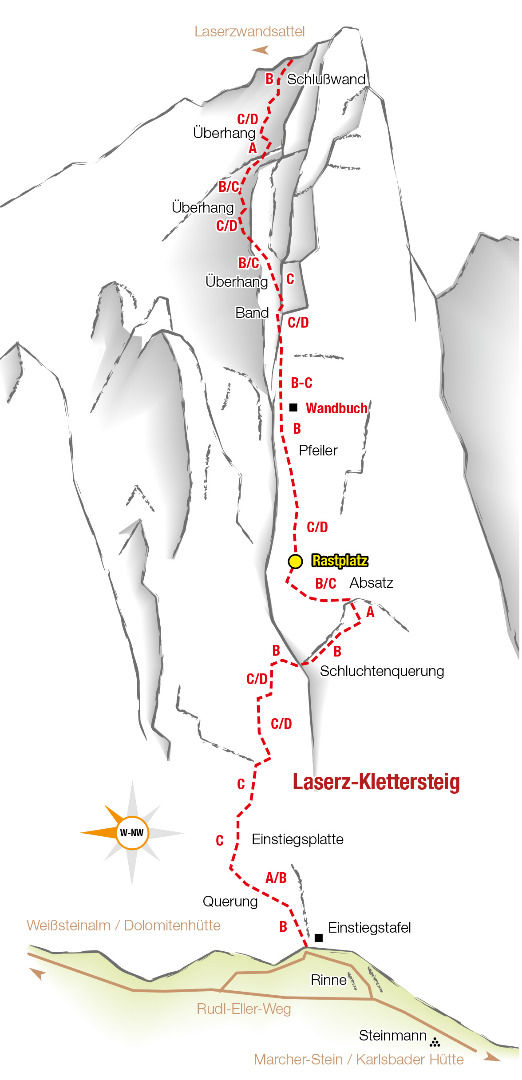
Lovely, challenging via ferrata route through the west face of the Kleine Laserzwand. At 620 m in length, enormously steep and with prolonged difficult sections, it presents a real challenge for tenacious and fit via ferrata users.

The entire route is secured throughout with a thick steel cable (set up in 2006).

Topos


Newsletter

Subscribe to our newsletter and receive the best tips every month for current offers, mountain tours, events and much more.