EN

Hiking in Prägraten am Großvenediger

Flying high on a hiking vacation

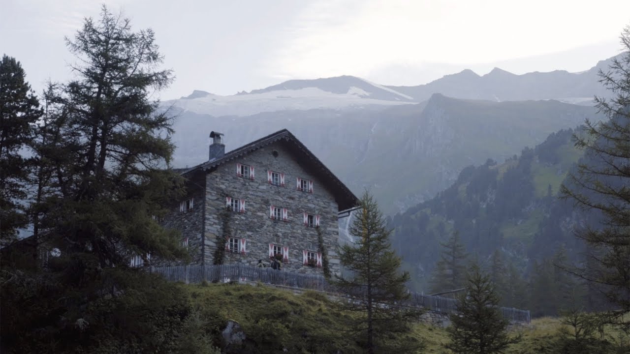
Prägraten am Großvenediger lives up to the description "mountaineering village" in more ways than one. As a certified member of "Austria's Hiking Villages", Prägraten a. G. is your base camp for your hiking adventure in Osttirol. Hikes on secluded trails make the hearts of outdoor enthusiasts beat faster: the Wiesbauerspitze (2,767 m) or Seewandspitze (3,022 m) provide breathtaking panoramas. If you want to be even closer to the sky, climb the Kreuzspitze (3,155 m), the Weißspitze (3,300 m) or the imposing Großvenediger (3,657 m). Hikes in these impressive surroundings can also be accompanied by the Venediger mountain guides. The experienced mountain guides convey the history and essence of the mountains in an engaging way and always strive to ensure your safety. In addition to high alpine hikes, moderate hut tours can also be tackled in Prägraten am Großvenediger. The range of managed huts is very broad.

Hiking trails in Prägraten

Prägraten am Großvenediger manages to do equal justice to challenging mountaineering, eventfullong-distance hikes and pleasanthut hikes. You will be talking about your adventures in the national park community for a long time to come. After all, beautiful mountain moments are etched in your memory.


We have put together a selection of desirable hiking destinations for you:

Muhs panorama trail

starting point:
Parking place Sägewerk
destination point:
Parking place Sägewerk
highest point:
2350 m
total walking time
6 h
distance
15.2 km
🔋
altitude meters uphill
1090 hm
🞽
difficulty
average

Hiking tour to Clarahütte

starting point:
Parkplatz Ströden
destination point:
Parkplatz Ströden
highest point:
2037 m
total walking time
5:30 h
distance
14.2 km
🔋
altitude meters uphill
645 hm
🞽
difficulty
average

Hiking tour to Stabanthütte 1.777m

starting point:
Parkplatz Sajat-/Stabanthütte
destination point:
Parkplatz Sajat-/Stabanthütte
highest point:
1770 m
total walking time
2 h
distance
3.3 km
🔋
altitude meters uphill
280 hm
🞽
difficulty
easy

Hiking tour to Islitzer Alm

starting point:
Parkplatz Ströden
destination point:
Parkplatz Ströden
highest point:
1500 m
total walking time
1:20 h
distance
3.7 km
🔋
altitude meters uphill
96 hm
🞽
difficulty
easy

Hiking tour to Nilljochhütte 1.990m from car park Bodenalm

starting point:
Parkplatz Bodenalm
destination point:
Parkplatz Bodenalm
highest point:
1970 m
total walking time
1:50 h
distance
4.4 km
🔋
altitude meters uphill
280 hm
🞽
difficulty
average

Hiking tour to Lasnitzenhütte

starting point:
Parking place Sägewerk
destination point:
Parking place Sägewerk
highest point:
1910 m
total walking time
4:35 h
distance
10.1 km
🔋
altitude meters uphill
620 hm
🞽
difficulty
easy

Hike to Neuen Reichenberger Hütte

starting point:
Parkplatz Ströden
destination point:
Parkplatz Ströden
highest point:
2600 m
total walking time
9 h
distance
9.1 km
🔋
altitude meters uphill
1210 hm
🞽
difficulty
average

Hiking tour to Neue Sajathütte 2.600m

starting point:
Parking place Sajat-/Stabanthütte
destination point:
Parking place Sajat-/Stabanthütte
highest point:
2600 m
total walking time
6:50 h
distance
10.3 km
🔋
altitude meters uphill
1080 hm
🞽
difficulty
average

Hiking tour to Eisseehütte

starting point:
Parkplatz Bodenalm
destination point:
Parkplatz Bodenalm
highest point:
2510 m
total walking time
5:45 h
distance
10.4 km
🔋
altitude meters uphill
820 hm
🞽
difficulty
average

Hiking tour to Essener Rostocker Hütte 2.208m

starting point:
Parkplatz Ströden
highest point:
2200 m
total walking time
4 h
distance
11.6 km
🔋
altitude meters uphill
800 hm
🞽
difficulty
average

Lasörling 3.098m

starting point:
Parkplatz Lasörlinghütte
destination point:
Lasörling 3.098m
highest point:
3098 m
total walking time
12 h
distance
21.9 km
🔋
altitude meters uphill
1940 hm
🞽
difficulty
difficult

Long-distance hiking trails in Prägraten

Hike further, experience more - that's the motto of the Osttirol long-distance hiking trails! If you embark on a multi-day hike, you will experience a wide variety of impressive experiences. Thundering waterfalls, rushing mountain streams, imposing three-thousand-metre peaks, unspoiltnature and a fascinatingworld of glaciers - there really are plenty of incentives to hike from hut to hut!


Das türkis-blaue Wasser der unteren Isel in Oberlienz. In der Mitte ist eine kleine Sandbank. Am Ufer wachsen viele grüne Bäume.
Iseltrail

A unique adventure route through a magical world of water wonders with individually selectable sections...

Blick auf den Adlerweg in Osttirol, Etappe 1. In einer Senke zwischen zwei Bergketten liegt eine Hütte, es fließt ein Bach und zwei Wege verlaufen entlang des Bachs.
Adlerweg Osttirol

Walk where the eagle flies: discover the most beautiful connection between the highest mountains in Austria, in the middle of the Nationalpark Hohe Tauern.

Blick auf die Neue Reichenbergerhütte vor einem Felsmassiv mit letzten Schneeresten.
Lasörling Höhenweg

In the mountains of Osttirol, in the Nationalpark Hohe Tauern , the Lasörlingkamm ridge stretches upwards with forest, alpine pastures and richly shaped peaks .

Zwei Personen kurz vor der Badener Hütte am Adlerweg in Osttirol, Etappe 4.
Venediger Höhenweg

The focal point of the natural wonder of the Venediger Group is the Großvenediger (3,657 m), the "World's Old Majesty".

Ein Bildstöckl am Straßenrand auf dem Virgentaler Sonnseitenweg. Im Hintergrund liegt noch Schnee auf den Berggipfeln.
Virgentaler Sonnseitenweg

On the paths of our ancestors: wonderful long-distance hike on the sun terrace of the Virgental valley in the Nationalpark Hohe Tauern.

Kreuzspitze summit cross
Hochalpiner Pilgerweg

Immerse yourself in a wonderful, natural mountain world on the highest crossroads in the Alps.

Umbal Valley
Hoch-Tirol-Trail

Cross-border long-distance hiking trail from South Tyrol to Osttirol

Lasörling hut
Lasörlingtreck

In 3 days through the picturesque mountain landscape of the Lasörling Group.

youtube video

Via ferratas in Prägraten

Prägraten a. G. offers a small but fine selection of via ferratas. All of them lead to imposing peaks with breathtaking views of the Osttirol mountains.

state: closed

Via ferrata Kreuzspitze

🄱
duration
30 min
length
100 m
🞽
difficulty
A/B
access time to the entry point
30 min
state: closed

Via ferrata "Rote Säule"

🄱
duration
1 h
length
350 m
🞽
difficulty
D/E
access time to the entry point
15 min
state: closed

Via ferrata "Türml" 2.845m

🄱
duration
30 min
length
100 m
🞽
difficulty
C
access time to the entry point
2:30 h

Bike and Hike in Prägraten

Do you love being out in nature both on foot and by bike? Then Osttirol is the right place for you, because here you can combine the two perfectly. We have put together the most beautiful bike and hike tours so that you can get on your bike without any detours. Our tips: The tour to the Umbal Falls is ideal for beginners, while those looking for the ultimate challenge can take on the bike and hike tour to the Großvenediger.

back
Next
Zwei Wanderer beim Gipfelsieg - Gipfel Seewandspitze Prägraten am Großvenediger
Sonnenaufgang am Gipfelkreuz der schneebedeckten Weissspitze. Der Himmel färbt sich in der Morgenröte und die Sonne erscheint langsam hinter der Bergkette.

The most beautiful bike & hike tours in Prägraten am Großvenediger

Bike & Hike Umbalfälle 1.660m

starting point:
Car park Matreier Goldried Bergbahnen 960m
destination point:
Umbalfälle 1.520m
🞽
difficulty bike
average
🞽
difficulty hike
easy
total distance
50.6 km
tour times
6.5 h

Bike & Hike Seewandspitze 3.024m

starting point:
Freizeitzentrum Gries
destination point:
Seewandspitze 3.024m
🞽
difficulty bike
average
🞽
difficulty hike
difficult
total distance
30.8 km
tour times
6 h

Bike & Hike Weißspitze 3.300m

starting point:
Parkplatz Freizeitzentrum Gries
destination point:
Weißspitze 3.300m
🞽
difficulty bike
average
🞽
difficulty hike
difficult
total distance
35.1 km
tour times
7.5 h

Bike & Hike Großvenediger 3.657m

starting point:
Prägraten-Hinterbichl 1.335m
destination point:
Großvenediger 3.657m
🞽
difficulty bike
average
🞽
difficulty hike
difficult
total distance
33.9 km
tour times
10 h
Newsletter

Subscribe to our newsletter and receive the best tips every month for current offers, mountain tours, events and much more.